


- 0:39 h
- 2.66 km
- 3 m
- 4 m
- 564 m
- 568 m
- 4 m
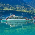
- Start: Boat landing Interlaken East
- Destination: Boat landing Bönigen
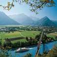
The walk starts behind the Interlaken East station at the boat landing, along the turquoise-blue Aare river the path leads you to the "Täggelibock" at Lake Brienz. On the lakeside path it continues past the Baggerseeli pond to the Bönigen beach bath. The grey Zweilütschine river is crossed there, which flows into the beautiful blue Lake Brienz. The walk ends at the boat landing in Bönigen.
Looking for more hiking tips in the Bernese Oberland?
Learn more about the various hiking options around Lake Thun and Lake Brienz.

Good to know
Pavements
Best to visit
Directions
Directions & Parking facilities
Additional information
Interlaken Tourism
Marktgasse 1
3800 Interlaken
Tel.: +41 33 826 53 00
mail@interlakentourism.ch
www.interlaken.ch
License (master data)
Author´s Tip / Recommendation of the author
- At Bistro Pistache by the Interlaken East boat landing there are delicious gelato in summer: https://pistache-bistro.ch/
- The Bönigen beach bath invites you to a refreshing swim in Lake Brienz or the heated pool. Guided kayak tours can be booked and SUPs as well as kayaks can be rented on site: https://www.strandbadboenigen.ch/
- A leisurely boat trip can be taken from the Bönigen boat landing: https://www.bls.ch
- The Jetboat Interlaken offers an adventurous ride on Lake Brienz: https://www.jetboat.ch/de/
Nearby


")
