- 5:40 h
- 8.79 km
- 1,780 m
- 1,408 m
- 2,966 m
- 1,558 m
- Start: Griesalp
- Destination: Schilthorn
From Griesalp, we first follow the signs towards Bundalp. At Dündenessli, keep left and mostly walk through forest until the Bundsteg junction. Here, keep left again and now follow the signs towards Dürrenberg. A short descent leads over the Gornerbach to Bundstäg. Slightly ascending on a hiking path to Alp Bürgli and then on an alp road, you now ascend to Alp Obere Dürreberg.
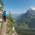
About 15 minutes and 100 meters altitude remain on the path towards Sefinafurgga. On a partially inconspicuous path, you ascend through steep grassy terrain to the Telli, with the view of the Blüemlisalp becoming ever more beautiful. The path remains steep until you see the Telli Pass. The terrain flattens, a nice place for a rest on the grassy area. The hiking trail changes character and the previously green ascent is replaced by a rocky landscape. At the Telli Pass at P. 2708, you get the impression of entering another world, resembling a Martian landscape. You continue straight on the faintly visible path towards the Schilthorn. Without significant elevation changes, soon the Tellisee is reached. Shortly before the Rote Härd junction, you meet the ridge and can enjoy the breathtaking view over the Sefine Valley towards the Bernese high Alps.
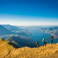
After an hour of hiking on the very scenic ridge trail, you reach the summit. Then take the cable car down to Stechelberg.

Good to know
Pavements
Best to visit
Directions
Equipment
Directions & Parking facilities
Outbound: by bus from Reichenbach station to Griesalp, Kurhaus
Return: by cable car to Stechelberg and bus to Lauterbrunnen station
Additional information
Literature
License (master data)
Safety guidelines
This route runs entirely or partly on alpine hiking trails!!!
Map
Nearby