


- 7:00 h
- 15.03 km
- 1,310 m
- 1,310 m
- 1,170 m
- 2,158 m
- 988 m
- Start: Kandersteg
- Destination: Kandersteg
From Kandersteg station we follow the signs directly to the Doldenhorn Hut. After about 2 km we reach the fork to the Doldenhorn Hut. Here stands an information board about geological events in the Doldenhorn massif area. Right at the beginning, the vertical rock step over the Bärentritt is overcome, which is already noticeable from Kandersteg. Walk quickly through the part below the rock wall – danger of rockfall. Then the path becomes flatter and leads above the rock step towards the west. At the Biberg junction turn left, where you quickly gain altitude in the forest. At one point a stream must be crossed; here caution and surefootedness are required. The lush forest flora is characterized by coltsfoot peppered with the blue shimmering coltsfoot leaf beetles. From the P.1817 junction it is about 15 minutes to the charmingly located Doldenhorn Hut.
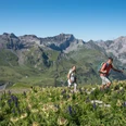
Back to P.1817 on the same path, from where we take the white-blue-white marked rock path. The key section is reached after just 5 minutes, so you have the opportunity to "look at" the place first if you are unsure about the crossing. The rock belt below the Fisialp is bypassed via a short ladder and an exposed traverse secured by a wire rope. About 20 minutes later, after the P.1804 junction, we are back on a white-red-white hiking trail. Soon the Fisialp, located above the tree line, is reached on this trail. We ascend over alpine meadows to the junction and the Fisi Schafberg shelter (P.2090). With hardly any more ascent, we continue the last part to the Jegertosse, initially through avalanche barriers and then over meadow terrain. The Jegertosse is only a frontal grassy crest of the Innere Fisistock, but the view of the glaciated flank of the Balmhorn and the surrounding valleys is simply overwhelming. And the flat meadow plateau invites you to stretch out your legs for a while before the long descent.
Back at Fisi Schafberg, we begin the descent to Kandersteg. This first passes through numerous alpine rose bushes and mountain pines, then through the forest. Initially still steep and with two wire-rope-secured sections, the path flattens and meets the Dürreschwand junction after the I de Schleife alp huts. Here we keep to the left and descend almost 300 meters more until we leave the forest and soon stand on the main road to Kandersteg. From here it is about 15 minutes back to the starting point at Kandersteg station.

Good to know
Pavements
Best to visit
Equipment
Directions & Parking facilities
Arrival: by train to Kandersteg station
Return: by train from Kandersteg station
Additional information
License (master data)
Safety guidelines
Map
swisstopo hiking map 264T Wildstrubel 1:50,000
Nearby
