- 5:40 h
- 12.46 km
- 1,200 m
- 1,200 m
- 1,111 m
- 2,248 m
- 1,137 m
- Start: Hotel Restaurant Alpenrose - Saxeten
- Destination: Hotel Restaurant Alpenrose - Saxeten
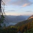
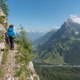
Some say the Morgenberghorn has to be scaled in the morning – yet hiking to the pinnacle of the Leissiggrat chain, with ever-changing views along the way, is a perfect choice for an autumnal afternoon. In this way, many hikers have come to enjoy the rarefied atmosphere of twilight at the summit. From the PostBus terminus at Saxeten, follow the narrow road into the valley for a few minutes. A well-maintained mountain track then turns uphill, passing through shady forested areas as well as fragrant alpine meadows. As you gradually ascend, the view widens ever more to encapsulate the entire Lake Brienz basin. After the cabins at Mittelberg, you reach the Renggli Pass, the point where the Saxeten valley becomes the Suld valley. The distinctive summits of the Dreispitz crown this unspoilt little valley in captivating style. After the pass, the route branches north in the direction of the Morgenberghorn, climbing very steeply at times. An exposed ridge is followed by a number of equally unsheltered passages on the western flank of the mountain. A cable is in place to help hikers traverse the slope, but even so these key spots call for absolute sure-footedness and a strong head for heights. After one final ascent – this time on a pleasantly grassy path – flags bearing the Swiss and Bernese coats of arms come into view on the summit, and the climber is instantly overwhelmed by the panoramic views. To the north, the view extends as far as Lakes Thun and Brienz, the Niederhorn, the Hohgant and the chain formed by the Augstmatthorn and the Brienzer Rothorn; to the south, the mighty rock mass of the Schwalmere and the chain of the high Bernese Alps beyond make for a fascinating sight. Hikers make their way back to the valley via the same route.

Good to know
Pavements
Best to visit
Directions
Equipment
Directions & Parking facilities
Additional information
License (master data)
Safety guidelines
Map
Nearby