


- 3:30 h
- 8.36 km
- 762 m
- 762 m
- 566 m
- 1,327 m
- 761 m
- Start: Interlaken Ost
- Destination: Interlaken Ost
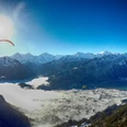
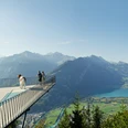
The Harder Kulm is the local mountain of Interlaken. Many paths lead up to the panorama restaurant with the Two-Lakes viewing platform, from which you can enjoy a magnificent view of Lake Thun and Lake Brienz. Far below lies Interlaken, and the hike up the Harder is worthwhile just for this deep view. The ascent from Interlaken Ost is the most beautiful, as you already have one or two surprising views of the town and lakes along the way – and in good weather, of the glacier-covered Jungfrau. Especially worth mentioning is the Hardermatte, a rest area with a barbecue and benches, from where you can see across to Beatenberg, Niederhorn, and Habkern. Once at the top, it’s “selfie time” on the Two-Lakes viewing platform. Afterwards, there are many options: those who want to walk a bit more can include the Harder theme trail in the descent, and those who prefer to relax can stop at the restaurant and take the funicular for the return journey.

Good to know
Pavements
Best to visit
Directions
Equipment
Directions & Parking facilities
Additional information
Interlaken Tourism, Tel. +41 (0) 33 826 53 00, www.interlaken.ch
Harderbahn, Rail Info Interlaken, Tel. +41 (0) 33 828 72 33, www.jungfrau.ch
Panorama Restaurant Harder Kulm, Tel. +41 (0) 33 828 73 11, www.restaurantharderkulm.ch
Literature
License (master data)
Author´s Tip / Recommendation of the author
Safety guidelines
Map
Map scale 1:50,000, 254T Interlaken.
Nearby


")
