


- 2:00 h
- 3.73 km
- 566 m
- 573 m
- 1,322 m
- 749 m
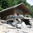
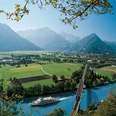
From the Harder Kulm valley station, the path leads you past the wildlife park to the Hohbühl pavilion. From here, the view over the "Bödeli" is already spectacular. Then it continues over roots and stones. After a few bends, the "Bleiki" is reached in about an hour. The view of Lake Brienz is spectacular.
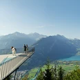
From here it goes further uphill towards the viewpoint at the "Hardermatte." Almost there – just a few more bends and you reach Harder Kulm. At the top, a magnificent view and a refreshing drink in the mountain restaurant await you.
Would you like to discover more hikes?
Find your favorite route in the Bernese Oberland.

Good to know
Pavements
Best to visit
Directions
Equipment
Directions & Parking facilities
Interlaken Ost train station is accessible by train
From Interlaken West train station, trains and buses run to Interlaken Ost train station
Additional information
Interlaken Tourism
Marktgasse 1
3800 Interlaken
Tel.: +41 33 826 53 00
mail@interlakentourism.ch
www.interlaken.ch
License (master data)
Author´s Tip / Recommendation of the author
Nearby


")
