


- 2:30 h
- 4.09 km
- 759 m
- 4 m
- 566 m
- 1,322 m
- 756 m
- Start: Interlaken Ost, railway station
- Destination: Panorama Restaurant Harder Kulm
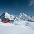
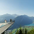
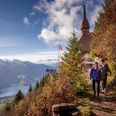
The trail leads from Interlaken Ost railway station along the River Aare to the valley station of the Harder Railway and in many, sometimes very steep, turns through the Bleiki forest to the Falkenfluh - a lookout point located above the Hardermannli rock face. The rock below the railings is practically perpendicular; Interlaken can be seen in a bird's eye view over the magnificent summits of the Eiger, Mönch and Jungfrau. The well-developed mountain trail then continues in a pleasant climb over wide Alpine meadows, with a view of Lake Thun and the pyramid-shape of the Niesen. Past the bustle on the terrace of the Harder Kulm mountain restaurant, the wide panorama trail leads to Harderbahn summit station.

Good to know
Best to visit
Directions
Equipment
Directions & Parking facilities
Additional information
(in the printed summer panoramic map of the Jungfrau Railways)
License (master data)
Safety guidelines
Nearby


")
