


- 3:00 h
- 1.77 km
- 731 m
- 993 m
- 1,170 m
- 1,628 m
- 458 m
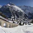
- Start: Mürren
- Destination: Gimmelwald
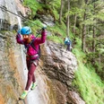
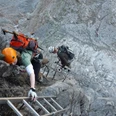
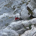
Through the unlit (and unmarked) tunnel to the south side of the tennis courts (overview board), then along the east side of the tennis court wall. From there, descent and traverses in the stepped terrain of the Mürrenfluh, alternating between rock and soil sections. Exposure increases, and soon the first key point is reached: the passage about 600 meters vertically above the Lauterbrunnen Valley with cable car station and parking lot – here there are really just metal rungs and lots of air under your feet. Then it continues, at times on limestone and at times in forest, along the Mürrenfluh. A short vertical ladder provides variety, as does the rather shaky three-wire bridge over the Mürrenbach. It is also crossed by the 60-meter-long zip line, which can only be done accompanied by mountain guides (sign "closed", so choose the right branch at the fork). Before and after the Sinterbach there are several ladder passages, some vertical, though exposure is small. A short three-wire bridge over a ditch offers more variety. At about 1300 meters, the lowest point of the via ferrata is reached. Soon after comes the finale: the 80-meter-long hanging bridge, which is very shaky and has no continuous rope to hold on properly. The safety rope you clip into is movable and fixed only every fourth suspension point; at least you can hold on to the supporting cable in the middle of the bridge... However, the hanging bridge can be avoided by exiting to the path between Mürren and Gimmelwald. After the hanging bridge, the Mürren via ferrata ends, only a short ascent remains to the overview board with route book and the cable car station Gimmelwald (1363 m, 3 hrs).

Good to know
Pavements
Best to visit
Directions
Mürren - Mürrenfluh - Gimmelwald
Equipment
We recommend the following equipment: official via ferrata gear, gloves, sturdy mountaineering boots, medium-sized backpack with hip belt, helmet, sun protection, rainwear, pocket first aid kit, picnic, sufficient fluids, mobile phone.
Directions & Parking facilities
Via Interlaken to Lauterbrunnen, then towards Stechelberg to the valley station of the Schilthornbahn.
Parking at the valley station of the Schilthornbahn (paid)
Getting there: via Interlaken Ost to Lauterbrunnen. By bus to Stechelberg/Schilthornbahn. Then take the aerial cableway up to Mürren.
Return: by aerial cableway from Gimmelwald to Stechelberg.
License (master data)
Safety guidelines
According to the via ferrata scale: C (K3, quite difficult).
Nearby
")