


- 5:30 h
- 18.06 km
- 550 m
- 540 m
- 565 m
- 760 m
- 195 m
- Start: Interlaken
- Destination: Brienz
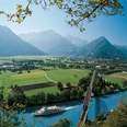
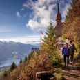
From Interlaken East station through the underpass to the boat station and along the Aare riverbank towards Lake Brienz. Rising at the railway bridge, switch to the other riverbank to the lowest houses of Goldswil. On the left, the Goldswil hill rises with the widely visible church ruin. The Romanesque-style church built in the 12th century once served the parishes of Ringgenberg, Unterseen and Habkern. It was abandoned in 1671 due to dilapidation and restored between 1940 and 1945 under the guidance of the Lake Shore Protection Association of Thun and Brienz Lakes. Hidden behind the now to be walked wooded ridge lies the idyllic Burgseewli. The view of Lake Brienz and the opposite mountain range of the Schynige Platte is magnificent.
Following a line of magnificent holiday homes, one now reaches the church of Ringgenberg and shortly afterwards turns to the main road (to the station 10 min). On a small road, it goes over a meadow ridge ridgeways and then almost flat over a meadow path to a quarry. A wonderful view of the lake far below. Over a wooded rocky ridge, you soon reach the ruin of Schadburg. East of the ruin, the path leads out of the small forest and first gently, then steeper, down to Niederried/Wyssechen (to the station 5 min). Here initially on the small road, then over a forest road uphill to the Farlouwi ditch and through the forest and over clearings slightly downhill to Oberried. Wonderful views of the lake, Iseltwald, and the nearby Schnäggeninsel. Now first on the main road to the station, then below the road to the nearby underpass to the church (nice viewpoint!) and eastwards over the meadow ridge to the forest. During the now easy hike through colorful mixed forest, you cross several ditches whose mountain streams cause havoc after storms, often interrupting the path. After the Unterweidli ditch (to the Ebligen stop 5 min), the path rises very steeply shortly and then leads in an entertaining up and down over Dorni–Ried down to Brienz. Through the narrow village lanes with their brown-burnt houses or over the lakeside promenade, you finally reach Brienz station. The mountain streams swollen disastrously after the heavy rains of summer 2005 unfortunately destroyed part of the village.

Good to know
Pavements
Best to visit
Directions
Interlaken - Ringgenberg - Niederried - Oberried - Brienz
Equipment
We recommend the following equipment: lightweight trekking shoes, light backpack, sun protection, rain jacket, pocket pharmacy, light picnic, sufficient fluids, mobile phone.
Directions & Parking facilities
Paid parking spaces at Interlaken East station
Outbound: By train to Interlaken East
Return: By train from Brienz
Additional information
Bernese Hiking Trails Association, Bern, Tel.: 031 340 01 01, E-Mail: info@beww.ch, Homepage: www.bernerwanderwege.ch
Literature
Hiking suggestion from the hiking book Jungfrau Region Brienz Lake - Oberhasli, hiking book series of the Bernese hiking trails
License (master data)
Safety guidelines
This route runs exclusively on marked paths of the hiking trail category.
Map
Swisstopo hiking map 1:50,000 254T Interlaken
Nearby


")
