


- 95:00 h
- 299.55 km
- 11,293 m
- 9,945 m
- 429 m
- 2,618 m
- 2,189 m
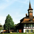
- Start: Bellelay
- Destination: Sustenpasshöhe
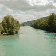
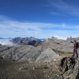
The ViaBerna is a multi-day hike through the entire canton of Bern. It runs from Bellelay in the Bernese Jura via the Central Plateau with its towns, rivers, and lakes to the Susten Pass in the Bernese Oberland. On the well over 300-kilometer-long and continuously marked route, 20 daily stages must be mastered. The long-distance hike impressively shows how varied the canton of Bern is. Practical is that the entire route runs on the nationwide hiking trail network, so tedious searching for the way is unnecessary. The technical difficulties are also limited, as you move exclusively on yellow and white-red-white marked hiking and mountain hiking trails. Also practical: all stage locations are connected to public transport, so except for a few exceptions, the route can also be hiked in day or weekend stages.

Good to know
Pavements
Best to visit
Directions
The route planning includes 20 hiking days with between three and a half and seven hours of pure walking time.
Stages:
1 Bellelay – Tramelan
2 Tramelan – St-Imier
3 St-Imier – Nods
4 Nods – Magglingen
5 Magglingen – Biel
6 Biel – Aarberg
7 Aarberg – Frauenkappelen
8 Frauenkappelen – Bern
9 Bern – Münsingen
10 Münsingen – Thun
11 Thun – Aeschi b/Spiez
12 Aeschi b/Spiez – Saxeten
13 Saxeten – Isenfluh
14 Isenfluh – Schynige Platte
15 Schynige Platte – First
16 First – Rosenlaui
17 Rosenlaui – Hasliberg-Reuti
18 Hasliberg-Reuti – Engstlenalp
19 Engstlenalp – Gadmen
20 Gadmen – Sustenpasshöhe
Equipment
Pack as much as necessary and as little as possible. The backpack should not weigh more than 10 to 12 kilos. For a multi-week hike, you don’t necessarily need more than for a two-day hike, especially if you can buy food for daily needs repeatedly along the way. Most mountain huts offer daily provisions.
. Backpack 30 to 40 liters (too large a pack tempts you to take more than necessary...)
. Clothing in layers: functional underwear as well as wind, cold, and rain protection (functional jacket, fleece/insulation jacket, softshell), hiking socks, rain pants, neckerchief, hat, gloves, and long underwear, possibly umbrella (depending on weather forecast)
. Spare clothes and socks
. Well-broken-in hiking boots with profile rubber soles
. Light slippers or sandals
. Toiletries, small terry towel, tissues, possibly earplugs, sun protection (hat, glasses, cream, lip balm)
. Light hut sleeping bag made of silk or cotton
. Light (head)lamp
. Possibly hiking poles
. Navigation aids and technical devices: maps, watch, mobile phone and possibly a camera with charging cable and memory cards, possibly binoculars
. Daily provisions, drinks, pocket knife, garbage bags
. Money (often only cash accepted in mountain huts), ID, GA/half-fare travelcard, writing utensils
. For emergencies: first aid kit with rescue blanket, blister plasters, bandages, and medications
Directions & Parking facilities
Arrival: By train via Biel and Sonceboz-Sombeval to Tavannes and post bus to Bellelay.
Return: By post bus from Susten Pass.
All stage starting points are accessible by public transport.
Additional information
Literature
Jochen Ihle / Toni Kaiser: The 101 most beautiful hikes in Switzerland. ISBN 978-3-03865-041-6, Rothus Medien, Solothurn, www.wandershop-schweiz.ch
Hiking Magazine SWITZERLAND, Special Edition 1/2022: ViaBerna. Rothus Medien, Solothurn, www.wandermagazin-schweiz.ch
License (master data)
Author´s Tip / Recommendation of the author
Complete the entire trekking in one go so that the rhythm typical of long-distance hikes can be established.
Safety guidelines
No particular difficulties, all day stages run on the marked Swiss hiking trail network and do not exceed difficulty level T3 (red-white marked mountain trails). Marking: green square with route number 38.
Map
Map scale 1:50,000, 222T Clos-du-Doubs, 232T Vallon de St-Imier, 233T Solothurn, 243T Bern, 253T Gantrisch, 254T Interlaken, 255T Sustenpass.
Our recommendations


Nearby


